
El Niño
 El
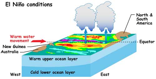
Nino happens when weakening trade winds (which sometimes even reverse
direction) allow the warmer water from the western Pacific to flow
toward the east. This flattens out the sea level, builds up warm surface
water off the coast of South America, and increases the temperature of
the water in the eastern Pacific.An El Nino condition results from
weakened trade winds in the western Pacific Ocean near Indonesia,
allowing piled-up warm water to flow toward South America.Since fish can
no longer access this rich food source, many of them die off. That is
why, these conditions are called "El Nino", or "the Christ Child", which
is what Peruvian fisherman call the particularly bad fishing period
around December. More importantly, the different water temperatures tend
to change the weather of the region.
El
Nino happens when weakening trade winds (which sometimes even reverse
direction) allow the warmer water from the western Pacific to flow
toward the east. This flattens out the sea level, builds up warm surface
water off the coast of South America, and increases the temperature of
the water in the eastern Pacific.An El Nino condition results from
weakened trade winds in the western Pacific Ocean near Indonesia,
allowing piled-up warm water to flow toward South America.Since fish can
no longer access this rich food source, many of them die off. That is
why, these conditions are called "El Nino", or "the Christ Child", which
is what Peruvian fisherman call the particularly bad fishing period
around December. More importantly, the different water temperatures tend
to change the weather of the region.
La Nina
 If,
on the other hand, the surface trade winds strengthen and with it the
east-west slopes and along with it the east-west oceanic temperature
gradients the resulting weather pattern leads to an anti-El Niño, that
is often referred to as La Niña. Such events are characterized by a high
positive Southern Oscillation Index (i.e. an increased westward
pressure gradient over the equatorial Pacific), stronger surface trade
winds over the central Pacific, and cooler SSTs in the eastern
equatorial Pacific. Such a weather pattern, on the other hand, is
associated with increased cyclone activity in the western Pacific, off
shore of eastern Australia, the Phillipines, and the western Atlantic
region.
If,
on the other hand, the surface trade winds strengthen and with it the
east-west slopes and along with it the east-west oceanic temperature
gradients the resulting weather pattern leads to an anti-El Niño, that
is often referred to as La Niña. Such events are characterized by a high
positive Southern Oscillation Index (i.e. an increased westward
pressure gradient over the equatorial Pacific), stronger surface trade
winds over the central Pacific, and cooler SSTs in the eastern
equatorial Pacific. Such a weather pattern, on the other hand, is
associated with increased cyclone activity in the western Pacific, off
shore of eastern Australia, the Phillipines, and the western Atlantic
region.
Post a Comment
Post a Comment